Where do I get information about current mountain conditions?
Once we get the gear and the training, there are steps we can take to stay safe every day we travel in the backcountry. Getting the forecast helps us understand changing avalanche conditions. From there we use maps, photos, and guidebooks to build a plan for our day in the mountains.
The avalanche danger fluctuates from day to day. Some days are more dangerous than others. For an individual to come up with their own accurate understanding of the avalanche danger on a given day can require years of experience and training along with the dedication to track daily changes in the snowpack and weather. Fortunately, many snowy regions in North America have avalanche centers staffed by teams of professionals working together to issue daily advisories, or forecasts, detailing avalanche conditions.
An avalanche forecast is your best tool to anticipate the conditions before you go into the mountains. Avalanche forecasts cover a specific area of the mountains for a given time period (between 12-24 hours). They’re usually issued once daily. Most forecasts start with simple messaging, like a danger rating and then dive deeper with details on conditions and how you can stay safe. The following sections describe the format used by NWAC and many centers in the United States.
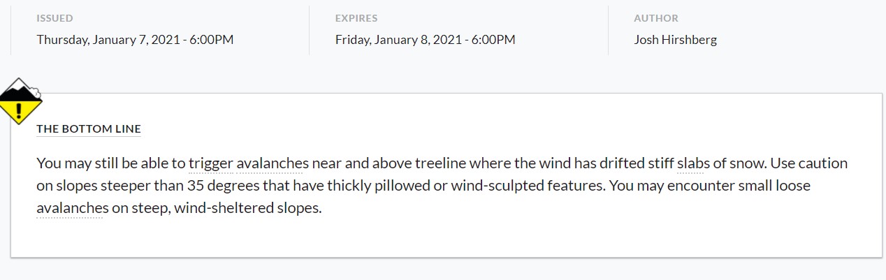
The Bottom Line
The first part of most avalanche forecasts is the Bottom Line. This is a short synopsis (often 3 sentences) of the day’s conditions written in plain english. It may include basic descriptions of the avalanche danger and any major contributing avalanche, snowpack, or weather factors. Most readers should be able to understand the Bottom Line even if they haven’t taken a formal avalanche course.
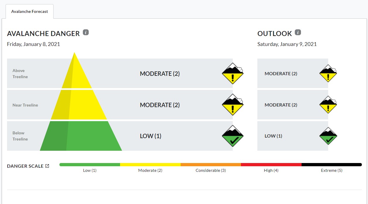
Avalanche Danger
Avalanche centers across North America all use the same avalanche danger scale to communicate conditions. Similar to other public safety scales, the danger ratings are Low, Moderate, Considerable, High, and Extreme. Each rating has a specific definition and associated color. Low danger is green and means that conditions are generally safe and avalanches are unlikely, though not impossible. At High danger (red), avalanche conditions are very dangerous and travel in avalanche terrain is not recommended. Avalanche forecasts frequently contain danger ratings issued for different elevation bands in the mountains. For example, a forecast may show Moderate danger at low elevation and Considerable danger for the middle and upper elevations. This gives you an idea of the trend in hazard as you ascend or descend the mountains. In addition to general travel recommendations, avalanche danger ratings also correspond to both the likelihood that you’ll encounter avalanches and the anticipated size, or consequences, of those avalanches. Likelihood and size are illustrated more explicitly by another part of the avalanche forecast, called the avalanche problems.
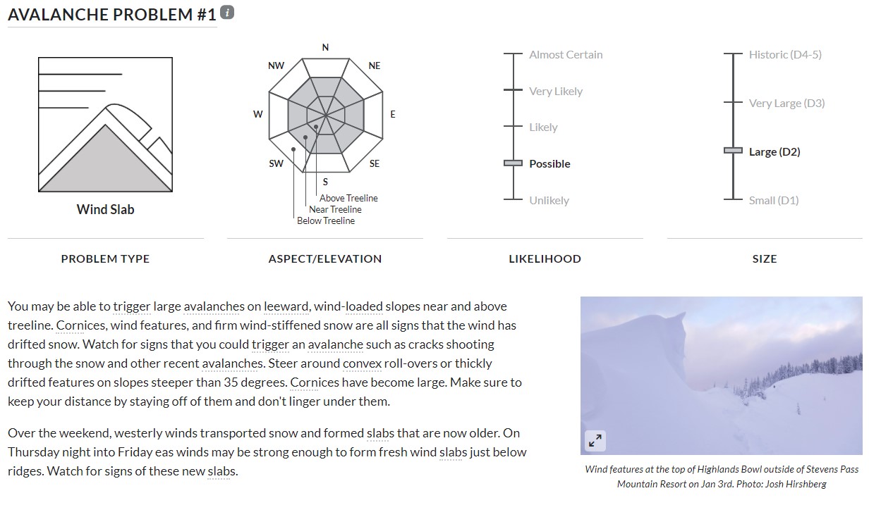
Avalanche Problems
The avalanche problem portion of a forecast is an extension of the danger scale which can give you a better picture of what types of avalanches you could encounter and how you can stay safe. This section describes the types of avalanches that are anticipated along with the size, likelihood, and distribution of those avalanches. This is typically outlined with graphics, icons, and a brief description that could include warning signs and ways to avoid these avalanches. The avalanche types are like different flavors or varieties of avalanches. Each problem type has its own characteristics. Some, like loose dry avalanches, are common, easy to trigger but rarely result in fatalities. These avalanches could be dangerous if travelers are unaware or unfamiliar with the danger or on slopes with high consequences. Other problem types may be difficult to trigger, but could result in unsurvivable and deadly avalanches. The avalanche problem section may be most applicable to readers who have taken at least a Level 1 avalanche course and/or have significant experience traveling in the backcountry. If you’re less experienced, you may end up with questions about the avalanche problem section of the forecasts. That said, reading this section can help develop your understanding of avalanche hazard and how to apply it to making decisions.
Forecast discussion
This is an optional section that forecasters may choose to use to discuss aspects of the day’s avalanche conditions that either are more detailed or may not fit into the previous sections. On some days the other sections of the forecast may cover all the details that the forecaster needs to convey. Other days the forecaster may use this section to discuss nuances such as notable snowpack observations, dynamic avalanche conditions, past avalanche cycles, or areas of uncertainty in the forecast.
Avalanche courses provide more knowledge to further apply the avalanche forecast. The forecast can be a great learning tool in itself. Many portions of the forecast include “information” (circle i) icons. You can click on the icons to read general explanations and descriptions.
Applying the forecast
You can use the forecast to create a plan for your day in the mountains. In addition to the forecast, maps, mapping phone apps, guidebooks, and knowledgeable locals can all be helpful for planning. Having a travel plan can also help us anticipate where we might encounter avalanche terrain, certain types of avalanches, or more dangerous conditions. You can draw a route on a paper map, create a track in an app, or write your trip plan in a field book to carry with you. Having this plan with you will help your group make decisions when you’re in the mountains. Applying the forecast and planning takes practice. You can learn more in depth trip planning in an avalanche course.
The avalanche forecast is your best tool for anticipating avalanche conditions and building a travel plan. These are steps that we take every day to help inform our decisions in the mountains. Getting the forecast can also help build your understanding of avalanches and further your avalanche education journey.
More resources
U.S. Avalanche Centers Avalanche.org
Canadian Avalanche Centers Avalanche.ca