Download the app here: Apple | Android
In late November 2023 NWAC launched a purpose built mobile app, Avy, that allows users to access weather and avalanche information for the Northwest Avalanche Center (NWAC) and the Sawtooth Avalanche Center (SAC). The app’s purpose is to provide a streamlined user experience for your core trip planning tools, including avalanche forecasts, weather forecasts, weather station data, and observations. Over the coming years, we hope to add the majority of avalanche centers across the country to the Avy app.
Avy was funded 100% through individual giving to the Northwest Avalanche Center. We are grateful to be part of a community that allows us to make ambitious projects like this happen!
Why We Built an App
Robust technology and communications are crucial to ensuring we can give people the best access to our entire lineup of forecasting and weather products. After all, the forecast, weather station data, and observations are only helpful if you can read and apply them.
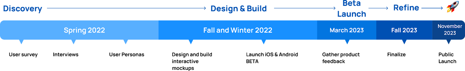
We began a formal discovery process in the spring of 2022 to better understand where we could improve technology platforms. We wanted to ensure that whatever we built filled a hole in our current products. We also wanted to make sure our limited funds weren’t better spent on improving the mobile version of the website or investing in some other project.
We gained a better understanding of where we could improve by surveying 1600 of our users online, running a market analysis to see what other apps and tech products were out there, conducting dozens of in-person interviews, and tapping the collective knowledge of the professional community. Through that process, we learned that while our 2021 website rebuild improved the mobile experience, there were still several friction points, including screen size, navigation, and limited cell service. Nearly 60% of website use is via mobile, so solving these issues was a priority.
We reviewed other mobile apps for viewing avalanche forecasts but found that they all redirect to our website and lack vital tools such as offline caching, notifications, and a thoughtful user interface that NWAC feels are imperative for trip planning and in-field decision making.
We weighed the pros and cons of optimizing our website for future mobile use, which would save costs, minimize the number of platforms we need to manage, and address some of our user challenges. Ultimately, the pros of improving user experience with simplified navigation, less scrolling, offline functionality, and opportunities for features that are not possible through the website such as push notifications convinced us the effort would be worth the cost.
How the app improves your experience
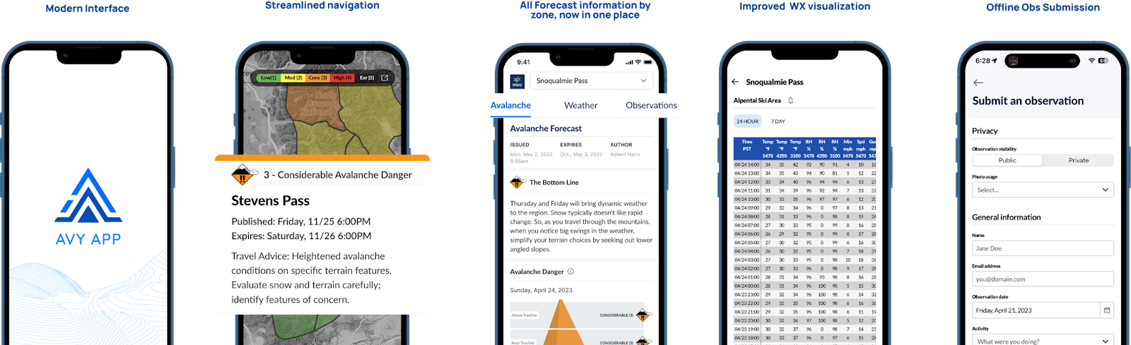
Consolidated Forecast View
Through user interviews and analytics from our website, we know that most of our users are accessing just one zone versus comparing across many. We designed the app to aggregate all the information for a single zone in one spot to minimize time spent looking for information. By selecting your zone from the main map you can quickly toggle between the avalanche forecast, weather forecast, weather station data, and observations for that zone. Additionally, one of the biggest complaints we received was that reading a forecast required significant scrolling, so we built collapsible sections. These sections not only limit scrolling but allow you to focus on each part of the forecast separately so you can plan your day better.
Offline Forecast Caching
Even if you’ve done your homework and planned your outing according to the Backcountry Bulletin, our avalanche forecasts are typically between 400-450 words (not including weather forecasts, data, or observations). The offline functionality for the app is included so that even when you’re deep in your outing you can revisit the hazard for the day. The app will automatically cache the forecast after you have viewed it. That means if you check the forecast when it comes out, your phone will hold onto that data until the next day. Now you can reference the forecast from the trailhead, in the field, and during your debrief.
Offline Observation Submission
Our forecasters rely on your observations to help them build the best possible forecast, and they’re also an essential tool for trip planning, so ease of submission was a focus when designing the app. When asked, many users said that though they intended to submit an observation, they forgot by the time they got home or felt they were no longer relevant. Now, you can submit your observation right from the trailhead or field whether you have cell reception or not. The app will cache your observation and automatically submit it once you reach better service.
Optimized Weather Station Tables and Data
NWAC’s weather station data are crucial to understanding what conditions you’ll find when you head out for the day. The updated weather station visualization in Avy was designed to help you get more out of the data. Now you can easily choose your station from 52 across Washington and Northern Oregon, including data from all WA ski areas. This update will optimize how you see weather station data on your phone, eliminating the confusion of the rows and columns getting mixed up when you zoom or scroll. And for those checking the weather stations every hour, we’ve included a quick link from the global navigation bar, accessible to you no matter where you are in the app.
Building a National App
Early in the process, we recognized the potential to build one app to serve all U.S. avalanche centers thanks to the National Avalanche Center (NAC). Among other responsibilities, the NAC manages the Avalanche Forecast Platform (AFP), through which 17 of the 22 US avalanche centers publish their forecasts. NWAC has worked closely with the NAC for years to build tools and resources that foster consistency for backcountry travelers across the US. The app connects directly to the AFP, meaning that with less development, we could share this tool with other centers.
While building a national tool does require more time and development resources, there are many benefits:
- Leverage fundraising: As one of the largest centers in the nation, NWAC has a consistent donor base, and knowing our members will show up year after year gives us the confidence to take on multi-year projects. No avalanche center has an excess budget, so sharing resources is imperative for giving nationwide users the best tools.
- Increase consistency: The AFP has laid the groundwork for building consistency across 17 of 22 US centers (plus the Colorado Avalanche Center which doesn’t use the AFP but does collaborate on forecast products) and Avy is the next step. Now not only will forecasts look the same but users only need to download one app to access all the forecasts they need. This tool is especially relevant to users who live and recreate close to multiple centers.
- Collaborate with other centers: Building a multi-center project means we get to tap the minds of smart folks across the country across the country and pull in their insights to make an even better product.
As a significant contributor to the development behind the NAC, the Sawtooth Avalanche Center (SAC) was the perfect center to partner with on bringing the multicenter functionality to life. We’re grateful to the NAC and partner centers like the SAC for laying the tech groundwork so that projects like Avy can support all backcountry users and bring you all more consistency across centers.
How The App Was Built
From discovery to build, NWAC’s Program Director, Charlotte Guard, worked with the group of highly-skilled folks that make up the NWAC tech committee. In an entirely volunteer capacity, they lent their skills to decide on a technical direction and begin the groundwork. The tech committee, made up of Steve Kuznetzov, Yulia Dubinina, and Zach Buzaid, has been meeting weekly since the spring of 2022 to bring the project from a whiteboard brainstorm to a fully functional app. All three bring their expertise as software engineers and avid backcountry skiers to help build the right product.
In the fall of 2022, we brought on two designers, Erica Miller and Kaitlin Kovacevich who, outside of their regular full-time jobs, worked together to design an app that both looks good and makes sense for users. We were also lucky to bring on Brian Sharon, a contract developer with decades of experience building software products, who pulled everything together.
NWAC spent approximately $140,000 to build the app, not including hundreds of volunteer hours. We estimate that had we outsourced the project to a development company the app would have cost two to three times as much to build.
Next steps
Now
As we head into forecast season, the staff and the tech committee will be working to get the word out to users of NWAC and the SAC, maintain the app and fix any bugs that may arise, and get feedback from our users and other stakeholders.
Next
Over the next few months, we plan to add more centers to test the app and potentially add to production depending on resources. We’re also looking to roll out new features, including push notifications, favorites, and search.
Future
We have a lot of big ideas for how to make the app an even better tool for our users, including a trip planning tool, sharing observations and forecasts, user profiles, and interactive tools. But first, we want to hear from you. What’s working? What’s missing? How could this tool be better?
How you can contribute
- Download the app here: Apple | Android
- Use the app & let us know what you think!
- Submit feedback via the button on the menu
- Email us developer@nwac.us
- Share it with your friends
- Rate it: rating the app helps it show up in more search terms letting even more users find the app