Observation Details
Name:
Chelan County Mountain RescueObservation Date:
December 17, 2022Submitted:
December 17, 2022Zone or Region:
East CentralActivity:
Skiing/SnowboardingLocation:
Kings CreekSigns of Unstable Snow
Observations
We trained on N/NE/E/SE slopes to 2800' today in cool, calm, and sunny weather. Not a lick of wind through 1300 with calm skies and an inversion that burned off by mid morning. Temps rose from 11F to 24F at the road with warmer pockets of sunshine.
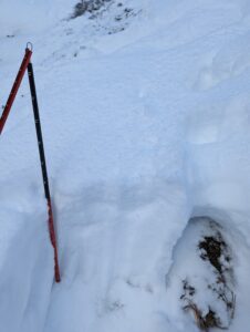
We found a HS 40-60cm with settlement cones of 20-35 cm since the 12/10 storm. Some old D1 storm slabs had created debris piles adjacent to road cuts, and probably ran sometime 12/8-12/10.
Solar slopes above the inversion are starting a diurnal cycle of melting and refreezing with weaker small grained facets or surface hoar above the crust. We didn't investigate below the crust to identify grains, although not for the potential of below crust facets.
Storm snow (top 20-30cm) is well faceted on polar aspects, with "Colorado rounds" to the ground below the 12/10 storm. Air temps in this lower drainage seem more conducive to further faceting than rounding at the moment.
With a shallow snowpack and a lack of slab structure, we didn't have a snowpack hypothesis to formally test today. However, the next round of storms and/or wind seem likely to fall on widespread weak snow in the Highway 97 corridor of the East Central zone.
We wish all backcountry and ski area travellers a safe holiday season and hope they consider supporting their local mountain rescue team this giving season.
Media


