Basic Information
Observation Details
Observation Date:
December 20, 2022Submitted:
December 20, 2022Observer:
NWAC Forecaster - Andy HarringtonZone or Region:
Snoqualmie PassLocation:
Kendall TreesSigns of Unstable Snow
Recent Avalanches?
YesCracking?
WidespreadCollapsing?
None ExperiencedMedia/Attachments


Advanced Information
Weather Summary
New/Recent Snowfall:
About 6" of new snow when we started the day and 6 more fell in the 3 hours we were away from the carIt went from steady snow to borderline nuking out there at times with 2"/hour rates. We were somehow away from the winds, but others told us that the winds were cranking in an area they had visited.
Avalanche Observations
| # | Date | Location | Size | Type | Bed Sfc | Depth | Trigger | Photos | Details |
|---|---|---|---|---|---|---|---|---|---|
| 30 |
Dec 20, 2022 () |
Commonwealth Basin W ft |
D1 | I-New/Old Interface | 0.5ft | N-Natural |


|
Report |
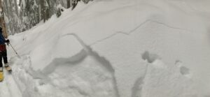
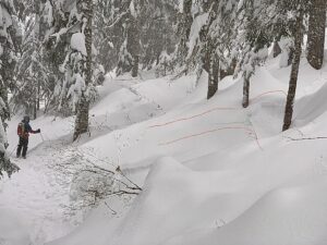
Widespread D1 slabs were observed in the BTL and NTL (small in many). Did not observe anything large enough to be called a D2, but some skiers mentioned they had found a larger one.
Snowpack Observations
The conditions in the Kendall area are well documented by our public contributors on the observation page. The snowpack was extremely sensitive in the morning hours, with remotely triggered slabs and a crown on almost every convexity or unsupported slope you could spot. We traveled to the top of the trees and just poked our heads out near the top. We observed some snow transport but were surprised at the lack of wind. Digging a quick pit, I got easy results at the new/old interface and at the 12/18 layer. Judging by the depth of most crowns I measured (5-7 inches), the thought is that most of these slabs were failing on low-density snow from the start of the storm (before the bump in temperatures). At the 12/18 interface, I was able to still identify some weak snow and rimed precipitation particles.
Blocks were failing easily on uptrack tests and it was easy to know that it was a heads up day right off the bat with so many signs of instability right in your face.
10:40 am
4780' SW
HS 132cm
HN ~15cm
12/18 @ 26cm
CT2 on new/old
CT7 on 12/18
ECTN9 on 12/18
Avalanche Problems
| Problem | Location | Distribution | Sensitivity | Size | Comments |
|---|---|---|---|---|---|
 Storm Slab
|
|
Layer Depth/Date: 13-18 cm |
